Farrer Road station
Revision as of 17:41, 2 September 2020 by Supernutorcrazy (talk | contribs) (Removed protection from "Farrer Road station")
!
|
TRAVEL ADVISORY | !
| ||||
|---|---|---|---|---|---|---|
Please refer here for more information.
| ||||||
| Template:Code/1 Farrer Road 花拉路 ஃபேரர் சாலை  | |
| Statistics | |
|---|---|
| Address | 71 Farrer Road Singapore 261006 |
| Line(s) | Circle Line |
| Structure | Underground |
| Connections | File:Bus Logo.png File:Taxi Logo.png |
| Abbreviation | FRR |
Farrer Road (CC20) is a Mass Rapid Transit (MRT) station on the Circle Line.
History
| Date | Event |
|---|---|
| 8 October 2011 | Station officially opened |
Construction sinkhole
On 24 May 2008, a section of Cornwall Gardens above a section between Holland Village and Farrer Road stations collapsed, creating a 3m deep hole. No one was injured, but some of the households lost their access to cable TV and Internet, as well as the water supply. This is the third road that caved in during the construction of the Circle Line.[1]
Artworks
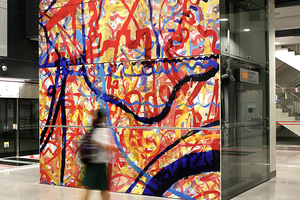
Circle Line: Art Lineage by Erzan Bin Adam
The artist roped in 300 members of the community to create this lively collection of lines and brushstrokes in a celebratory riot of colour. The art is meant to represent the “in-between spaces” where identity is formed – not by what is there, but what is in-between.[2]

Layout
| L2 | Overhead Bridge | ||
|---|---|---|---|
| L1 | Street Level | ||
| B1 | Concourse | Faregates, Ticketing Machines, Passenger Service Centre | |
| B2 | Service Level | Restricted access | |
| B3 | Template:Route/3 | ||
| Platform A/B | |||
| |||
Exits
| Exit | Disabled-Access | Location/Nearby |
|---|---|---|
| A | Farrer Road | |
| B | Farrer Road, Empress Road |
Transport Services
First/Last Train Timing
| Destination | First Train | Last Train | ||
|---|---|---|---|---|
| Mon − Fri | Sat | Sun & P.H. | Daily | |
| File:MRT000.png Circle Line | ||||
| CC1Dhoby Ghaut | 05:43 | 05:43 | 06:04 | 23:23 |
| CC7Mountbatten | – | – | – | 00:00 |
| CC12Bartley | – | – | – | 00:24 |
| CC29HarbourFront | 05:34 | 05:34 | 05:59 | 23:29 |
| CC26Pasir Panjang | – | – | – | 23:59 |
| CC23one-north | – | – | – | 00:15 |
Bus
| Bus Stop | Exit | Bus Service |
|---|---|---|
| 11119 | Farrer Rd Stn Exit A |
5N 48 93 153 165 174 186 855 961 961M
|
| 11111 | Farrer Rd Stn Exit B |
48 93 153 165 174 186 855 961 961M
|
References
- ↑ "Road above Circle line construction site caves in". Channel NewsAsia (24 May 2008). Archived on 26 May 2008.
- ↑ "Art in Transit". Land Transport Authority.
| [ V • T • E ] | ||
|---|---|---|
| Stations | Dhoby Ghaut • Bras Basah • Esplanade • Promenade • Nicoll Highway • Stadium • Mountbatten • Dakota • Paya Lebar • MacPherson • Tai Seng • Bartley • Serangoon • Lorong Chuan • Bishan • Marymount • Caldecott • Bukit Brown • Botanic Gardens • Farrer Road • Holland Village • Buona Vista • one-north • Kent Ridge • Haw Par Villa • Pasir Panjang • Labrador Park • Telok Blangah • HarbourFront | |
| CCL6Keppel • Cantonment • Prince Edward Road | ||
| Circle Line ExtensionPromenade • Bayfront • Marina Bay | ||
| Rolling Stock | 830 • 830C • 851E | |
| Depots | Kim Chuan | |
| Others | Bridging Service | |