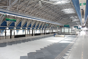
Gul Circle station
Revision as of 20:55, 19 December 2022 by Wekelwrady (talk | contribs)
!
|
TRAVEL ADVISORY | !
| ||||
|---|---|---|---|---|---|---|
Please refer here for more information. | ||||||
| EW30 Gul Circle 卡尔圈 கல் சர்க்கல்*Graphic From SGTrains/Wikipedia/LTA | |
| Statistics | |
|---|---|
| Address | 7A Tuas Road Singapore 637288 |
| Line(s) | East–West Line |
| Structure | Elevated |
| Connections | |
| Abbreviation | GCL |
Gul Circle (EW30) is a Mass Rapid Transit (MRT) station on the East–West Line. It is the tallest station with a height of 33m above ground level.[1]
History[edit]
| Date | Event |
|---|---|
| 18 June 2017 | Station officially opened |
| 16 November 2017 - 19 November 2017 | Station closed due to the Joo Koon train collision[2] |
| 20 November 2017 - 26 May 2018 | Station (towards Pasir Ris) closed due to the Joo Koon train collision[3] (Except 10, 17 December 2017, 29 April 2018 and 6, 13, 20 May 2018) |
| 10, 17 December 2017 | Station closed due to the upgrading of signaling system on the East–West Line[4] |
| 14, 21, 28 March 2021 | Station closed due to the replacement of electrical cable on the East–West Line[5] |
| 4, 11, 18, 25 April 2021 | |
| 2, 9, 16, 23 May 2021 |
Layout[edit]
| L4 |
| |||||||
|---|---|---|---|---|---|---|---|---|
| Platform B/D | ||||||||
| ||||||||
| L3 |
| |||||||
| Platform A/C | ||||||||
| ||||||||
| L2 | Concourse | Faregates, Ticketing Machines, Passenger Service Centre | ||||||
| L1 | Street Level | |||||||
Exits[edit]
| Exit | Disabled-Access | Location/Nearby |
|---|---|---|
| A | Tuas Road, Tuas Fire Station | |
| B | Tuas Road, Tuas Avenue 3 |
Transport Services[edit]
First/Last Train Timing[edit]
| Destination | First Train | Last Train | ||
|---|---|---|---|---|
| Mon − Fri | Sat | Sun & P.H. | Daily | |
| EW1Pasir Ris | 05:26 | 05:26 | 05:56 | 23:26 |
| EW33Tuas Link | 05:30 | 05:30 | 06:00 | 00:41 |
Bus[edit]
- More travel information: Alternative Travel Method
| Bus Stop | Exit | Bus Service | |
|---|---|---|---|
| Gul Circle Stn Exit A Tuas Rd |
|
192 193
| |
| Gul Circle Stn Exit B Tuas Rd |
|
192 193
|
References[edit]
- ↑ "MRT Tuas West Extension to soar above the ground". Christopher Tan (Straits Times, 3 February 2015).
- ↑ "Joint Statement by the Land Transport Authority (LTA) & SMRT - Joo Koon train incident". Land Transport Authority (15 November 2017).
- ↑ "Update on Train Services on Tuas West Extension". Land Transport Authority (16 November 2017).
- ↑ "2 full-day shutdowns, shorter operating hours for 19 NSEWL MRT stations in December: LTA, SMRT". Channel NewsAsia (21 November 2017).
- ↑ "Selected East-West Line MRT stations to close on Sundays for cable replacement works". Channel NewsAsia (2 March 2021).
| [ V • T • E ] | ||
|---|---|---|
| Stations | Pasir Ris • Tampines • Simei • Tanah Merah • Bedok • Kembangan • Eunos • Paya Lebar • Aljunied • Kallang • Lavender • Bugis • City Hall • Raffles Place • Tanjong Pagar • Outram Park • Tiong Bahru • Redhill • Queenstown • Commonwealth • Buona Vista • Dover • Clementi • Jurong East • Chinese Garden • Lakeside • Boon Lay • Pioneer • Joo Koon • Gul Circle • Tuas Crescent • Tuas West Road • Tuas Link | |
| Changi Airport ExtensionTanah Merah • Expo • Changi Airport | ||
| Rolling Stock | 151 • 651 • 751B • 151A • 151B • 151C • R151 | |
| Depots | Changi • Ulu Pandan • Tuas • East Coast | |
| Others | Bridging Service | |
