Difference between revisions of "Central Area"
| (2 intermediate revisions by one other user not shown) | |||
| Line 3: | Line 3: | ||
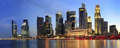
The '''Central Area''', also called '''The City''', is the city centre of [[Singapore]]. Located in the south-eastern part of the Central Region, the Central Area consists of 11 [[Planning Areas]], namely, [[Downtown Core]], [[Marina East]], [[Marina South]], the [[Museum]], [[Newton]], [[Orchard]], [[Outram]], [[River Valley]], [[Rochor]], the [[Singapore River]] and [[Straits View]], as defined by the Urban Redevelopment Authority. The term '''Central Business District''' ('''CBD''') has also been used to describe most of the Central Area as well, although its boundaries lie within the Downtown Core. It has a land area of approximately 17.84 km<sup>2</sup> | The '''Central Area''', also called '''The City''', is the city centre of [[Singapore]]. Located in the south-eastern part of the Central Region, the Central Area consists of 11 [[Planning Areas]], namely, [[Downtown Core]], [[Marina East]], [[Marina South]], the [[Museum]], [[Newton]], [[Orchard]], [[Outram]], [[River Valley]], [[Rochor]], the [[Singapore River]] and [[Straits View]], as defined by the Urban Redevelopment Authority. The term '''Central Business District''' ('''CBD''') has also been used to describe most of the Central Area as well, although its boundaries lie within the Downtown Core. It has a land area of approximately 17.84 km<sup>2</sup> | ||
The Central Area surrounds the banks of the Singapore River and | The Central Area surrounds the banks of the Singapore River and Marina Bay where the first settlements on the island were established shortly after the arrival of Sir Stamford Raffles in 1819. Surrounding the Central Area is the rest of the Central Region. The Central Area shares boundaries with [[Novena]] to the north, [[Kallang]] to the north and north-east, [[Tanglin]] to the north-west and west, [[Bukit Merah]] to the south-west and [[Marine Parade]] to the east. The south-easternmost limits of the city is enclosed in by [[Marina Barrage]], where the mouth of Marina Bay meets the Singapore Strait. | ||
==Notable Structures== <!---only include national monuments, government buildings and/or other notable/unique structures (DO NOT INCLUDE SCHOOLS OR SHOPPING MALLS)---> | ==Notable Structures== <!---only include national monuments, government buildings and/or other notable/unique structures (DO NOT INCLUDE SCHOOLS OR SHOPPING MALLS)---> | ||
| Line 16: | Line 16: | ||
*Istana Heritage Gallery | *Istana Heritage Gallery | ||
*MINT Museum of Toys | *MINT Museum of Toys | ||
* | *National Gallery Singapore | ||
** | **City Hall | ||
** | **Old Supreme Court | ||
*National Museum of Singapore | *National Museum of Singapore | ||
*Peranankan Museum | *Peranankan Museum | ||
| Line 69: | Line 69: | ||
*The Fullerton Hotel Singapore | *The Fullerton Hotel Singapore | ||
|} | |} | ||
<!-- | |||
==Politics== | ==Politics== | ||
{| class="toccolours"; "wikitable" border="1" cellpadding="3" style="border-collapse:collapse; text-align:center" | {| class="toccolours"; "wikitable" border="1" cellpadding="3" style="border-collapse:collapse; text-align:center" | ||
| Line 75: | Line 75: | ||
!Incumbent | !Incumbent | ||
!Role | !Role | ||
|} | |} | ||
--> | |||
==Links== | ==Links== | ||
{{Planning Area}} | {{Planning Area}} | ||
Latest revision as of 02:34, 10 July 2020

The Central Area, also called The City, is the city centre of Singapore. Located in the south-eastern part of the Central Region, the Central Area consists of 11 Planning Areas, namely, Downtown Core, Marina East, Marina South, the Museum, Newton, Orchard, Outram, River Valley, Rochor, the Singapore River and Straits View, as defined by the Urban Redevelopment Authority. The term Central Business District (CBD) has also been used to describe most of the Central Area as well, although its boundaries lie within the Downtown Core. It has a land area of approximately 17.84 km2
The Central Area surrounds the banks of the Singapore River and Marina Bay where the first settlements on the island were established shortly after the arrival of Sir Stamford Raffles in 1819. Surrounding the Central Area is the rest of the Central Region. The Central Area shares boundaries with Novena to the north, Kallang to the north and north-east, Tanglin to the north-west and west, Bukit Merah to the south-west and Marine Parade to the east. The south-easternmost limits of the city is enclosed in by Marina Barrage, where the mouth of Marina Bay meets the Singapore Strait.
Notable Structures[edit]
Museums[edit]
Theatres[edit]
Parks[edit]
|
Iconic Structures[edit]
Places of worship[edit]
Others[edit]
|
Links[edit]
| Planning Areas | View • Talk • Edit | ||
|---|---|---|---|
| Central | Bishan • Bukit Merah • Bukit Timah • Downtown Core1 • Geylang • Kallang • Marina East1 • Marina South1 • Marine Parade • Museum1 • Newton1 • Novena • Orchard1 • Outram1 • Queenstown • River Valley1 • Rochor1 • Singapore River1 • Southern Islands • Straits View1 • Tanglin • Toa Payoh | ||
| East | Bedok • Changi • Changi Bay • Pasir Ris • Paya Lebar • Tampines | ||
| North | Central Water Catchment • Lim Chu Kang • Mandai • Sembawang • Simpang • Sungei Kadut • Woodlands • Yishun | ||
| North-East | Ang Mo Kio • Hougang • North-Eastern Islands • Punggol • Seletar • Sengkang • Serangoon | ||
| West | Boon Lay • Bukit Batok • Bukit Panjang • Choa Chu Kang • Clementi • Jurong East • Jurong West • Pioneer • Tengah • Tuas • Western Islands • Western Water Catchment | ||
| 1: Located within the Central Area | |||