Difference between revisions of "Tampines"
| (3 intermediate revisions by 3 users not shown) | |||
| Line 2: | Line 2: | ||
Tampines is located at the southern part of Singapore's east region and is made out of 1 subzone, Simei. The planning area is bordered by [[Bedok]] and [[Paya Lebar]] to the west, [[Pasir Ris]] to the north, [[Changi]] to the east and the Singapore Straits to the south. | Tampines is located at the southern part of Singapore's east region and is made out of 1 subzone, Simei. The planning area is bordered by [[Bedok]] and [[Paya Lebar]] to the west, [[Pasir Ris]] to the north, [[Changi]] to the east and the Singapore Straits to the south. | ||
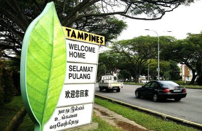
[[File:Welcome_Home_Tampines.jpg|thumb|right|400px|A welcome sign in [[Tampines]] (Tampines Avenue 7)]] | |||
==Notable Structures== | ==Notable Structures== | ||
===Education=== | ===Education=== | ||
| Line 13: | Line 13: | ||
! | ! | ||
*Angsana Primary School | *Angsana Primary School | ||
*Changkat | *Changkat Primary School | ||
*Chongzheng Primary School | *Chongzheng Primary School | ||
*East Spring Primary School | *East Spring Primary School | ||
| Line 52: | Line 52: | ||
!East View Secondary School | !East View Secondary School | ||
|Merged with East Spring Secondary School in 2019 | |Merged with East Spring Secondary School in 2019 | ||
|- | |||
!Qiaonan Primary School | |||
|Merged with Griffiths Primary School in 2014 and became Angsana Primary School | |||
|- | |- | ||
!Tampines Junior College | !Tampines Junior College | ||
| Line 73: | Line 76: | ||
*''{{Stn|Xilin| MRT station}} (Opening in 2026)'' | *''{{Stn|Xilin| MRT station}} (Opening in 2026)'' | ||
===Roads=== | |||
For list of roads visit, [[List of Roads in Tampines]] | |||
===Government-related=== | ===Government-related=== | ||
*[[Tampines#Bedok North Depot|Bedok North Bus Depot]] | *[[Tampines#Bedok North Depot|Bedok North Bus Depot]] | ||
Latest revision as of 18:17, 17 September 2024
Tampines is a planning area and residential town located in the East Region of Singapore. Measuring at approximately 20.89 km2, Tampines ranks the 9th, 3rd & 15th in terms of size, population & density respectively. It is the third largest town in Singapore by area and also is the third most populated new town, following Bedok and Jurong West. It is the regional centre for the East Region. The town is so named because in the 1900s a large forest of ironwood trees, or tempinis, were there.
Tampines is located at the southern part of Singapore's east region and is made out of 1 subzone, Simei. The planning area is bordered by Bedok and Paya Lebar to the west, Pasir Ris to the north, Changi to the east and the Singapore Straits to the south.

Notable Structures[edit]
Education[edit]
| Primary Schools | Secondary Schools | Tertiary & Other Institutions |
|---|---|---|
|
|
|
| Defunct Schools | Notes |
|---|---|
| East View Primary School | Merged with Junyuan Primary School in 2019 |
| East View Secondary School | Merged with East Spring Secondary School in 2019 |
| Qiaonan Primary School | Merged with Griffiths Primary School in 2014 and became Angsana Primary School |
| Tampines Junior College | Merged with Meridian Junior College in 2019 |
Transportation[edit]
Roads[edit]For list of roads visit, List of Roads in Tampines [edit]
Shopping Centres/Malls[edit]
Parks[edit]
Health[edit]
Bus Interchanges/Terminals[edit]Bedok North Depot[edit]
Changi Business Park Terminal[edit]
Tampines Interchange[edit]
Tampines Concourse Interchange[edit]
Tampines North Interchange[edit]
Politics[edit]
Links[edit]
|
|||||||||||||||||||||||||||||||||||||||||||||||||||||||||||||||||||||||||||||||||||||||||||||||||||||||||||||||||||||||||||||||||||||||||||||||||||||