Difference between revisions of "Kovan station"
Jump to navigation
Jump to search
m |
Wekelwrady (talk | contribs) |
||
| (20 intermediate revisions by 3 users not shown) | |||
| Line 1: | Line 1: | ||
{{Infobox/Station | {{Infobox/Station | ||
|Code={{Code| | |TA1=RNE | ||
|Code={{Code/S|NE13|NEL}} | |||
|Name=Kovan<br>高文<br>கோவன் | |Name=Kovan<br>高文<br>கோவன் | ||
|Img=[[File:Kovan-NEL.png|centre|300px]] | |Img=[[File:Kovan-NEL.png|centre|300px]] | ||
| Line 6: | Line 7: | ||
{{Infoline|Address|900 Upper Serangoon Road<br>Singapore 534799}} | {{Infoline|Address|900 Upper Serangoon Road<br>Singapore 534799}} | ||
{{Infoline|Line(s)|{{NEL}}}} | {{Infoline|Line(s)|{{NEL}}}} | ||
{{Infoline|Connections| | {{Infoline|Structure|Underground}} | ||
{{Infoline|Connections|{{Icon|Bus|B|25px|o={{CSS/BUS|s=|f=}}|a=Bus|d=inline}} {{Icon|Taxi|W|25px|o={{CSS/LTA|s=|f=}}|a=Taxi|d=inline}}}} | |||
{{Infoline|Abbreviation|KVN}} | {{Infoline|Abbreviation|KVN}} | ||
}} | }} | ||
'''Kovan (NE13)''' is | '''Kovan (NE13)''' is a [[Mass Rapid Transit]] (MRT) station on the {{NEL}}. | ||
==History== | ==History== | ||
| Line 16: | Line 18: | ||
!width=150|Date!!Event | !width=150|Date!!Event | ||
|- | |- | ||
|20 June 2003||Station officially | |20 June 2003||Station officially opened | ||
|} | |} | ||
With the opening of the station, Hougang South Bus Interchange ceased operations in February 2004 and its services were transferred to Hougang Central Bus Interchange. | With the opening of the station, Hougang South Bus Interchange ceased operations in February 2004 and its services were transferred to Hougang Central Bus Interchange. | ||
== | ==Artworks== | ||
''The Trade- | *[[File:NE13-The Trade off.png|300px]]<br>{{NEL}}: ''The Trade-off'' by Eng Tow<br>This work juxtaposes topographical maps from 1945 and the present day, making a commentary on time and progress in the Kovan area. One largely agricultural and the other depicting expressways and new developments, the maps are made from granite and stainless steel inlays set on the station floor and complemented by cartographic symbols.<ref>[//www.lta.gov.sg/content/ltagov/en/getting_around/public_transport/a_better_public_transport_experience/art_in_transit.html "Art in Transit"]. Land Transport Authority.</ref> | ||
==Layout== | ==Layout== | ||
| Line 35: | Line 37: | ||
|- | |- | ||
!rowspan=3|B2 | !rowspan=3|B2 | ||
|Platform A||{{ | |colspan=2| | ||
{| class="mw-collapsible mw-collapsed" style="width:100%;" | |||
!{{Layout/Platform|A|NEL}} | |||
|style='padding-right:.5em;'|{{Layout/Arrow|NEL|0}} {{Layout/Station|NE1}} | |||
|style='padding-left:.5em;border-left:1px solid;width:200px'|'''Service Map''' | |||
|- | |||
|colspan=3| | |||
<div style='overflow-x:scroll;white-space:nowrap;max-width:75vw;'> | |||
{{Layout/Map|NE13|#000|#fff|c=NEL}} {{Layout/Map|NE12|c=NEL}} {{Layout/Map|NE11|c=NEL}} {{Layout/Map|NE10|c=NEL}} {{Layout/Map|NE9|c=NEL}} {{Layout/Map|NE8|c=NEL}} {{Layout/Map|NE7|c=NEL}} {{Layout/Map|NE6|c=NEL}} {{Layout/Map|NE5|c=NEL}} {{Layout/Map|NE4|c=NEL}} {{Layout/Map|NE3|c=NEL}} {{Layout/Map|NE1|c=NEL|r=}} | |||
</div> | |||
|} | |||
|- | |- | ||
|colspan=2 class="platform"|Platform A/B | |colspan=2 class="platform"|Platform A/B | ||
|- | |- | ||
|Platform B||{{ | |colspan=2| | ||
{| class="mw-collapsible mw-collapsed" style="width:100%;" | |||
!{{Layout/Platform|B|NEL}} | |||
|style='padding-right:.5em;'|{{Layout/Arrow|NEL|180}} {{Layout/Station|NE17}} | |||
|style='padding-left:.5em;border-left:1px solid;width:200px'|'''Service Map''' | |||
|- | |||
|colspan=3| | |||
<div style='overflow-x:scroll;white-space:nowrap;max-width:75vw;'> | |||
{{Layout/Map|NE17|c=NEL}} {{Layout/Map|NE16|c=NEL}} {{Layout/Map|NE15|c=NEL}} {{Layout/Map|NE14|c=NEL}} {{Layout/Map|NE13|#000|#fff|c=NEL|r=}} | |||
</div> | |||
|} | |||
|} | |} | ||
| Line 48: | Line 70: | ||
|A||{{WAB}}||style="text-align:left;"|Upper Serangoon Road | |A||{{WAB}}||style="text-align:left;"|Upper Serangoon Road | ||
|- | |- | ||
|B|| ||style="text-align:left;"|Upper Serangoon Road, Lowland Road | |B||{{NWAB}}||style="text-align:left;"|Upper Serangoon Road, Lowland Road | ||
|- | |- | ||
|C||{{WAB}}||style="text-align:left;"|Heartland Mall-Kovan | |C||{{WAB}}||style="text-align:left;"|Heartland Mall-Kovan | ||
| Line 60: | Line 82: | ||
!width=70|Mon − Fri!!width=70|Sat!!width=70|Sun & P.H.!!width=70|Daily | !width=70|Mon − Fri!!width=70|Sat!!width=70|Sun & P.H.!!width=70|Daily | ||
|- | |- | ||
!colspan=5 | !colspan=5 style="{{CSS/NEL|s=|t=}}text-align:center;"|{{Icon|MRT|W|20px|d=inline}} {{NEL|style={{CSS/NEL|bg=none|s=|t=}}}} | ||
{{ | {{Timing|NE1||05:51|05:51|06:11|23:37|nv=}} | ||
{{ | {{Timing|NE17||06:09|06:10|06:30|00:20|nv=}} | ||
|} | |} | ||
===Bus=== | ===Bus=== | ||
:''More travel information: [[Alternative Travel Method/Kovan|Alternative Travel Method]]'' | |||
{|class="wikitable" | {|class="wikitable" | ||
!width=240|Bus Stop!!width=30|Exit!!width=300|Bus Service | !width=240|Bus Stop!!width=30|Exit!!width=300|Bus Service | ||
{{BusGuide| | {{BusGuide|{{BS63031}}| {{Exit/Cell|B}} }}{{Bus/80}} {{Bus/81}} {{Bus/82}} {{Bus/101}} {{Bus/107}} {{Bus/107|a=M}} {{Bus/112}} {{Bus/113}} {{Bus/136}} {{Bus/153}} | ||
{{BusGuide| | {{BusGuide|{{BS63039}}| {{Exit/Cell|C}} }}{{Bus/80}} {{Bus/81}} {{Bus/82}} {{Bus/101}} {{Bus/107}} {{Bus/107|a=M}} {{Bus/112}} {{Bus/113}} {{Bus/115}} {{Bus/119}} {{Bus/136}} {{Bus/153}} | ||
|} | |} | ||
Revision as of 22:36, 4 January 2023
!
|
TRAVEL ADVISORY | !
| ||||
|---|---|---|---|---|---|---|
| ||||||
Kovan 高文 கோவன் NE13 | |
 | |
| Station Information | |
|---|---|
| Address | 900 Upper Serangoon Road Singapore 534799 |
| Line(s) | North East Line |
| Structure | Underground |
| Connections | |
| Abbreviation | KVN |
Kovan (NE13) is a Mass Rapid Transit (MRT) station on the North East Line.
History
| Date | Event |
|---|---|
| 20 June 2003 | Station officially opened |
With the opening of the station, Hougang South Bus Interchange ceased operations in February 2004 and its services were transferred to Hougang Central Bus Interchange.
Artworks
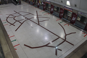
North East Line: The Trade-off by Eng Tow
This work juxtaposes topographical maps from 1945 and the present day, making a commentary on time and progress in the Kovan area. One largely agricultural and the other depicting expressways and new developments, the maps are made from granite and stainless steel inlays set on the station floor and complemented by cartographic symbols.[1]

Layout
| L1 | Street Level | Heartland Mall-Kovan | ||||||
|---|---|---|---|---|---|---|---|---|
| B1 | Concourse | Faregates, Ticketing Machines, Passenger Service Centre | ||||||
| B2 |
| |||||||
| Platform A/B | ||||||||
| ||||||||
Exits
| Exit | Disabled-Access | Location/Nearby |
|---|---|---|
| A | Upper Serangoon Road | |
| B | Upper Serangoon Road, Lowland Road | |
| C | Heartland Mall-Kovan |
Transport Services
First/Last Train Timing
| Destination | First Train | Last Train | ||
|---|---|---|---|---|
| Mon − Fri | Sat | Sun & P.H. | Daily | |
| NE1HarbourFront | 05:51 | 05:51 | 06:11 | 23:37 |
| NE17Punggol | 06:09 | 06:10 | 06:30 | 00:20 |
Bus
- More travel information: Alternative Travel Method
| Bus Stop | Exit | Bus Service | |
|---|---|---|---|
Kovan Stn Exit B Upp S'goon Rd | NE13Kovan Heartland Mall Kovan |
B |
80 81 82 101 107 107M 112 113 136 153 |
Kovan Stn Exit C Upp S'goon Rd | NE13Kovan Heartland Mall Kovan |
C |
80 81 82 101 107 107M 112 113 115 119 136 153 |
References
- ↑ "Art in Transit". Land Transport Authority.
| [ V • T • E ] | ||
|---|---|---|
| Stations | HarbourFront • Outram Park • Chinatown • Clarke Quay • Dhoby Ghaut • Little India • Farrer Park • Boon Keng • Potong Pasir • Woodleigh • Serangoon • Kovan • Hougang • Buangkok • Sengkang • Punggol • Punggol Coast | |
| Rolling Stock | 751A • 751C • 851E | |
| Depots | Sengkang | |
| Others | Bridging Service | |