Difference between revisions of "Alternative Travel Method/Maxwell"
Jump to navigation
Jump to search
Wekelwrady (talk | contribs) |
Wekelwrady (talk | contribs) |
||
| Line 165: | Line 165: | ||
|- | |- | ||
|{{TE17| }} | |{{TE17| }} | ||
|{{TE18| }} {{Exit|{{Exit/Cell|3}}}} {{ArrowD|2=Walk along Neil Rd towards Kreta Ayer Rd and turn right,<br> then turn left at the junction of New Bridge Rd|3=5}} {{TE17| }} {{Exit|{{Exit/Cell|4}}}} | |{{TE18| }} {{Exit|{{Exit/Cell|3}}}} {{ArrowD|2=Walk along Neil Rd towards Kreta Ayer Rd and turn right,<br> then turn left at the junction of New Bridge Rd|3=5}} {{TE17| }} {{Exit|{{Exit/Cell|3}}{{Exit/Cell|4}}}} | ||
!5 | !5 | ||
|- | |- | ||
| Line 177: | Line 177: | ||
|- | |- | ||
|{{TE20| }} | |{{TE20| }} | ||
|{{ | |{{TE18| }} {{Exit|{{Exit/Cell|3}}}} {{ArrowD|2=Walk along Neil Rd towards Kreta Ayer Rd and turn right,<br> then turn left at the junction of New Bridge Rd|3=5}} {{EW16| }} {{Exit|{{Exit/Cell|3}}{{Exit/Cell|4}}}} {{ArrowD|EWL| {{EWL}} |4 ~ 9}} {{EW14| }} {{ArrowD|NSL| {{NSL}} |2 ~ 7}} {{NS27| }} | ||
! | !11 ~ 21 | ||
|- | |- | ||
|{{TE22| }} | |{{TE22| }} | ||
| | |{{TE18| }} {{Exit|{{Exit/Cell|3}}}} {{ArrowD|2=Walk along Neil Rd towards Kreta Ayer Rd and turn right,<br> then turn left at the junction of New Bridge Rd|3=5}} {{EW16| }} {{Exit|{{Exit/Cell|3}}{{Exit/Cell|4}}}} {{ArrowD|EWL| {{EWL}} |4 ~ 9}} {{EW14| }} {{ArrowD|NSL| {{NSL}} |2 ~ 7}} {{NS27| }} {{Exit|{{Exit/Cell|1}}}} {{ArrowD|3=6}} {{BS03381}} {{ArrowD|BUS| {{Bus/400}} |5 ~ 35}} {{BS03369}} | ||
{ | |||
| | |||
{| class="wikitable mw-collapsible mw-collapsed" style="max-width:45em;" | {| class="wikitable mw-collapsible mw-collapsed" style="max-width:45em;" | ||
!Remarks | !Remarks | ||
| Line 198: | Line 188: | ||
* You may consider the {{TEL| Bridging Service}} as an alternative due to the low frequency of bus service {{Bus/400}}. | * You may consider the {{TEL| Bridging Service}} as an alternative due to the low frequency of bus service {{Bus/400}}. | ||
|} | |} | ||
!22 ~ 62 | |||
! | |||
|} | |} | ||
Revision as of 20:31, 12 April 2024
Notes
- The suggested route assumed that there is no train disruption on the rest of the MRT network.
- The list of bus service plying between the bus stops are listed accordingly by their similar travelling time and not by the origin-destination pair.
- Other train options are available at EW15Tanjong Pagar & EW16NE3TE17Outram Park within walking distance.
Thomson–East Coast Line
Woodlands North to Caldecott
| Going To | Route(s) | Estimated Travel Time (mins) | |||||||||||||||
|---|---|---|---|---|---|---|---|---|---|---|---|---|---|---|---|---|---|
| TE1Woodlands North |
|
68 ~ 102 | |||||||||||||||
| TE2NS9Woodlands |
|
50 ~ 70 | |||||||||||||||
| TE3Woodlands South |
|
63 ~ 96 | |||||||||||||||
| TE4Springleaf |
|
47 ~ 98 | |||||||||||||||
| TE5Lentor |
|
39 ~ 84 | |||||||||||||||
| TE6Mayflower |
|
42 ~ 78 | |||||||||||||||
| TE7Bright Hill |
|
42 ~ 83 | |||||||||||||||
| TE8Upper Thomson |
|
36 ~ 82 | |||||||||||||||
| TE9CC17Caldecott |
|
28 ~ 64 | |||||||||||||||
Stevens to Gardens by the Bay
| Going To | Route(s) | Estimated Travel Time (mins) | ||||||||||
|---|---|---|---|---|---|---|---|---|---|---|---|---|
| TE11DT10Stevens |
|
26 ~ 46 | ||||||||||
| TE12Napier |
|
26 ~ 63 | ||||||||||
| TE13Orchard Boulevard |
|
21 ~ 58 | ||||||||||
| TE14NS22Orchard |
|
14 ~ 45 | ||||||||||
| TE15Great World |
|
23 ~ 48 | ||||||||||
| TE16Havelock | TE18Maxwell
Walk along Neil Rd towards Kreta Ayer Rd and turn right, then turn left at the junction of New Bridge Rd[ 5 mins ] Aft Duxton Plain Pk New Bridge Rd [ 10 ~ 25 mins ] Havelock Stn Exit 3 Zion Rd
|
15 ~ 30 | ||||||||||
| TE17EW16NE3Outram Park | TE18Maxwell
Walk along Neil Rd towards Kreta Ayer Rd and turn right, then turn left at the junction of New Bridge Rd[ 5 mins ] TE17EW16NE3Outram Park
|
5 | ||||||||||
| TE19Shenton Way |
|
15 ~ 45 | ||||||||||
| TE20NS27CE2Marina Bay | TE18Maxwell
Walk along Neil Rd towards Kreta Ayer Rd and turn right, then turn left at the junction of New Bridge Rd[ 5 mins ] EW16NE3TE17Outram Park
East–West Line [ 4 ~ 9 mins ] EW14NS26Raffles Place North–South Line [ 2 ~ 7 mins ] NS27CE2TE20Marina Bay |
11 ~ 21 | ||||||||||
| TE22Gardens by the Bay | TE18Maxwell
Walk along Neil Rd towards Kreta Ayer Rd and turn right, then turn left at the junction of New Bridge Rd[ 5 mins ] EW16NE3TE17Outram Park
East–West Line [ 4 ~ 9 mins ] EW14NS26Raffles Place North–South Line [ 2 ~ 7 mins ] NS27CE2TE20Marina Bay
Walk[ 6 mins ] The Sail Marina Blvd [ 5 ~ 35 mins ] Gardens by the Bay Stn Exit 1 Marina Gdns Dr
|
22 ~ 62 | ||||||||||
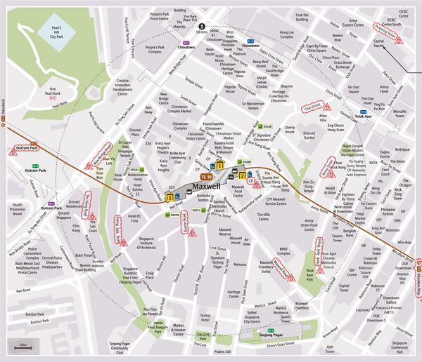
Reference Map
See Also
| [ V • T • E ] | ||
|---|---|---|
| Stations | Woodlands North • Woodlands • Woodlands South • Springleaf • Lentor • Mayflower • Bright Hill • Upper Thomson • Caldecott • Mount Pleasant • Stevens • Napier • Orchard Boulevard • Orchard • Great World • Havelock • Outram Park • Maxwell • Shenton Way • Marina Bay • Marina South • Gardens by the Bay • Founders' Memorial • Tanjong Rhu • Katong Park • Tanjong Katong • Marine Parade • Marine Terrace • Siglap • Bayshore • Bedok South • Sungei Bedok | |
| Rolling Stock | T251 | |
| Depots | Mandai • East Coast | |
| Others | Bridging Service | |
