Difference between revisions of "Farrer Park station"
Jump to navigation
Jump to search
(→Bus: Removing svc.66.) |
|||
| (12 intermediate revisions by 6 users not shown) | |||
| Line 1: | Line 1: | ||
{{Infobox | {{Travel Advisory|REW=showonly}} | ||
| | {{Infobox | ||
|header=<td colspan=2><div style='display:flex;justify-content:space-between'><div><big>'''Farrer Park'''</big><br>花拉公园<br>ஃபேரர் பார்க்</div><div style='display:flex;align-items:flex-end;flex-direction:column'><div style='display:flex;align-items:center'>{{Code/S|NE8|NEL}}</div><div>'''Abbr:''' FRP</div></div></div>[[File:Farrer Park-NEL.png|centre|300px]]</td> | |||
|info= | |||
| | |||
{{Infoline|Address|250 Race Course Road<br>Singapore 218703}} | {{Infoline|Address|250 Race Course Road<br>Singapore 218703}} | ||
{{Infoline|Line(s)|{{NEL}}}} | {{Infoline|Line(s)|{{NEL}}}} | ||
{{Infoline|Structure|Underground}} | {{Infoline|Structure|Underground}} | ||
{{Infoline|Connections| | {{Infoline|Connections|{{Icon|Bus|B|25px|style={{CSS/BUS|xfc=|xbc=}}|a=Bus}} {{Icon|Taxi|W|25px|style={{CSS/LTA|xfc=|xbc=}}|a=Taxi}}}} | ||
}} | }} | ||
| Line 35: | Line 32: | ||
|- | |- | ||
!rowspan=3|B2 | !rowspan=3|B2 | ||
|colspan=2|{{ | |colspan=2| | ||
{| class="mw-collapsible mw-collapsed" style="width:100%;" | |||
!{{Layout/Platform|A|NEL}} | |||
|style='padding-right:.5em;'|{{Layout/Arrow|NEL|0}} {{Layout/Station|NE1}} | |||
|style='padding-left:.5em;border-left:1px solid;width:200px'|'''Service Map''' | |||
|- | |||
|colspan=3| | |||
<div style='overflow-x:scroll;white-space:nowrap;max-width:75vw;'> | |||
{{Layout/Map|NE8|#000|#fff|c=NEL}} {{Layout/Map|NE7|c=NEL}} {{Layout/Map|NE6|c=NEL}} {{Layout/Map|NE5|c=NEL}} {{Layout/Map|NE4|c=NEL}} {{Layout/Map|NE3|c=NEL}} {{Layout/Map|NE1|c=NEL|r=}} | |||
</div> | |||
|} | |||
|- | |- | ||
|colspan=2 class="platform"|Platform A/B | |colspan=2 class="platform"|Platform A/B | ||
|- | |- | ||
|colspan=2|{{ | |colspan=2| | ||
{| class="mw-collapsible mw-collapsed" style="width:100%;" | |||
!{{Layout/Platform|B|NEL}} | |||
|style='padding-right:.5em;'|{{Layout/Arrow|NEL|180}} {{Layout/Station|NE18}} | |||
|style='padding-left:.5em;border-left:1px solid;width:200px'|'''Service Map''' | |||
|- | |||
|colspan=3| | |||
<div style='overflow-x:scroll;white-space:nowrap;max-width:75vw;'> | |||
{{Layout/Map|NE18|c=NEL}} {{Layout/Map|NE17|c=NEL}} {{Layout/Map|NE16|c=NEL}} {{Layout/Map|NE15|c=NEL}} {{Layout/Map|NE14|c=NEL}} {{Layout/Map|NE13|c=NEL}} {{Layout/Map|NE12|c=NEL}} {{Layout/Map|NE11|c=NEL}} {{Layout/Map|NE10|c=NEL}} {{Layout/Map|NE9|c=NEL}} {{Layout/Map|NE8|#000|#fff|c=NEL|r=}} | |||
</div> | |||
|} | |||
|} | |} | ||
| Line 48: | Line 65: | ||
|A||{{WAB}}||style="text-align:left;"|Farrer Square (U/C) | |A||{{WAB}}||style="text-align:left;"|Farrer Square (U/C) | ||
|- | |- | ||
|B|| ||style="text-align:left;"|Race Course Road, Tessensohn Road | |B||{{NWAB}}||style="text-align:left;"|Race Course Road, Tessensohn Road | ||
|- | |- | ||
|C||{{ | |C||{{NWAB}}||style="text-align:left;"|Race Course Road, Birch Road | ||
|- | |- | ||
|D|| ||style="text-align:left;"|Gloucester Road | |D||{{WAB}}||style="text-align:left;"|Gloucester Road | ||
|- | |- | ||
|E|| ||style="text-align:left;"|Northumberland Road | |E||{{NWAB}}||style="text-align:left;"|Northumberland Road | ||
|- | |- | ||
|F|| ||style="text-align:left;"|Roberts Lane | |F||{{NWAB}}||style="text-align:left;"|Roberts Lane | ||
|- | |- | ||
|G|| ||style="text-align:left;"|Serangoon Road, Perumal Road | |G||{{NWAB}}||style="text-align:left;"|Serangoon Road, Perumal Road | ||
|- | |- | ||
|H||{{WAB}}||style="text-align:left;"|City Green, City Square Mall | |H||{{WAB}}||style="text-align:left;"|City Green, City Square Mall | ||
| Line 72: | Line 89: | ||
!width=70|Mon − Fri!!width=70|Sat!!width=70|Sun & P.H.!!width=70|Daily | !width=70|Mon − Fri!!width=70|Sat!!width=70|Sun & P.H.!!width=70|Daily | ||
|- | |- | ||
!colspan=5 style="{{CSS/NEL|s=|t=}}text-align:center;"| | !colspan=5 style="{{CSS/NEL|s=|t=}}text-align:center;"|{{Icon|MRT|W|20px|d=inline}} {{NEL|style={{CSS/NEL|bg=none|s=|t=}}}} | ||
{{Timing|NE1||06:02|06: | {{Timing|NE1||06:02|06:02|06:22|23:48|nv=}} | ||
{{Timing| | {{Timing|NE18||05:57|05:57|06:17|00:09|nv=}} | ||
|} | |} | ||
===Bus=== | ===Bus=== | ||
:''More travel information: [[Alternative Travel Method/Farrer Park|Alternative Travel Method]]'' | |||
{|class="wikitable" | {|class="wikitable" | ||
!width=240|Bus Stop!!width=30|Exit!!width=300|Bus Service | !width=240|Bus Stop!!width=30|Exit!!width=300|Bus Service | ||
{{BusGuide| | {{BusGuide|{{BS50251|landmark=}}| {{Exit/Cell|A}} }}{{Bus/131}} {{Bus/141}} | ||
{{ | {{BusGuide|{{BS50279|landmark=}}| {{Exit/Cell|D}} }}{{Bus/141}} | ||
{{BusGuide|{{BS07211|landmark=}}| {{Exit/Cell|G}} }}{{Bus/21}} {{Bus/23}} {{Bus/64}} {{Bus/65}} {{Bus/67}} {{Bus/125}} {{Bus/130}} {{Bus/139}} {{Bus/141}} {{Bus/147}} {{Bus/857}} | |||
|} | |} | ||
Latest revision as of 23:39, 23 April 2025
!
|
TRAVEL ADVISORY (25/4/2025) | !
| ||||
|---|---|---|---|---|---|---|
| ||||||
Farrer Park 花拉公园 ஃபேரர் பார்க் NE8 Abbr: FRP  |
|
| Address | 250 Race Course Road Singapore 218703 |
|---|---|
| Line(s) | North East Line |
| Structure | Underground |
| Connections | |
Farrer Park (NE8) is a Mass Rapid Transit (MRT) station on the North East Line.
History[edit]
| Date | CollapseEvent |
|---|---|
| 20 June 2003 | Station officially opened |
Artworks[edit]
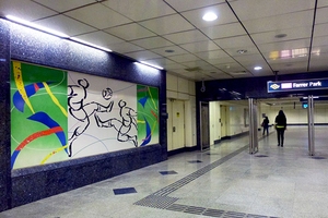
North East Line: Rhythmic Exuberance by Poh Siew Wah
Wall murals on football, swimming and athletics exuberantly capture the surrounding area’s sporting past – a stadium and turf club were located here in pre-war days. The black ink brush drawings alternate with paintings of abstract shapes and lines in pastel colours to depict movement, dynamism and vibrancy.[1]

Layout[edit]
| L1 | Street Level | City Square Mall | |||
|---|---|---|---|---|---|
| B1 | Concourse | Faregates, Ticketing Machines, Passenger Service Centre, Transitlink Ticket Office | |||
| B2 |
| ||||
| Platform A/B | |||||
| |||||
Exits[edit]
| Exit | Disabled-Access | Location/Nearby |
|---|---|---|
| A | Farrer Square (U/C) | |
| B | Race Course Road, Tessensohn Road | |
| C | Race Course Road, Birch Road | |
| D | Gloucester Road | |
| E | Northumberland Road | |
| F | Roberts Lane | |
| G | Serangoon Road, Perumal Road | |
| H | City Green, City Square Mall | |
| I | City Green, City Square Mall |
Transport Services[edit]
First/Last Train Timing[edit]
| Destination | First Train | Last Train | ||
|---|---|---|---|---|
| Mon − Fri | Sat | Sun & P.H. | Daily | |
NE1 CC29 NE1 CC29 |
06:02 | 06:02 | 06:22 | 23:48 |
NE18 |
05:57 | 05:57 | 06:17 | 00:09 |
Bus[edit]
- More travel information: Alternative Travel Method
| Bus Stop | Exit | Bus Service |
|---|---|---|
50251 Farrer Pk Stn Exit A Rangoon Rd |
A |
131 141 |
50279 Farrer Pk Stn Exit D Gloucester Rd |
D |
141 |
07211 Aft Farrer Pk Stn Exit G S'goon Rd |
G |
21 23 64 65 67 125 130 139 141 147 857 |
References[edit]
- ↑ "Art in Transit". Land Transport Authority.
| [ V • T • E ] | ||
|---|---|---|
| Stations | HarbourFront • Outram Park • Chinatown • Clarke Quay • Dhoby Ghaut • Little India • Farrer Park • Boon Keng • Potong Pasir • Woodleigh • Serangoon • Kovan • Hougang • Buangkok • Sengkang • Punggol • Punggol Coast | |
| Rolling Stock | 751A • 751C • 851E | |
| Depots | Sengkang | |
| Others | Bridging Service | |