Difference between revisions of "Farrer Road station"
m (→Layout) |
m |
||
| Line 1: | Line 1: | ||
{{Infobox/Station | {{Infobox/Station | ||
|TA1=RCC | |||
|Code={{Code|1|CCL|CC20}} | |Code={{Code|1|CCL|CC20}} | ||
|Name=Farrer Road<br>花拉路<br>ஃபேரர் சாலை | |Name=Farrer Road<br>花拉路<br>ஃபேரர் சாலை | ||
Revision as of 08:10, 30 May 2020
!
|
TRAVEL ADVISORY | !
| ||||
|---|---|---|---|---|---|---|

| ||||||
Farrer Road 花拉路 ஃபேரர் சாலை 1 | |
| *Graphic From SGTrains/Wikipedia/LTA | |
| Statistics | |
|---|---|
| Address | 71 Farrer Road Singapore 261006 |
| Line(s) | Circle Line |
| Connections | File:Bus Logo.png File:Taxi Logo.png |
| Abbreviation | FRR |
Farrer Road (CC20) is an underground Mass Rapid Transit (MRT) station on the Circle Line.
History
| Date | Event |
|---|---|
| 8 October 2011 | Station officially opens |
On 24 May 2007, a section of Cornwall Gardens Road above a section between Holland Village and Farrer Road stations collapsed, creating a 3 metre deep hole. No one was injured, but some of the households lost their access to cable TV and Internet, as well as the water supply. This is the third road that caved in during the construction of the Circle Line.
Art in Transit
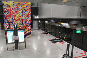
Art Lineage by Erzan Adam, uses lines as a key element to emphasise unity in art and in the community, members of the public were invited to paint coloured lines in any way they liked over three canvasses. The artist then digitised and overlayered the images to create a single piece, which is now displayed on the lift shaft in the station.[1]
Layout
| L2 | Overhead Bridge | |
|---|---|---|
| L1 | Street Level | |
| B1 | Concourse | Faregates, Ticketing Machines, Passenger Service Centre |
| B2 | Service Level | Restricted access |
| B3 | Template:RailRoute/3 | |
| Platform A/B | ||
| Template:RailRoute/1 | ||
Exits
| Exit | Disabled-Access | Location/Nearby |
|---|---|---|
| A | Farrer Road | |
| B | Farrer Road, Empress Road |
Transport Services
First/Last Train Timing
| Destination | First Train | Last Train | ||
|---|---|---|---|---|
| Mon − Fri | Sat | Sun & P.H. | Daily | |
| File:MRT000.png Circle Line
Template:MRTTime Template:MRTTime Template:MRTTime Template:MRTTime Template:MRTTime Template:MRTTime | ||||
Bus
| Bus Stop | Exit | Bus Service |
|---|---|---|
| 11119 | Farrer Rd Stn Exit A |
5N 48 93 153 165 174 186 855 961 961M |
| 11111 | Farrer Rd Stn Exit B |
48 93 153 165 174 186 855 961 961M |
References
- ↑ Martin, Mayo. "Circle Line Art! The final destination(s)! A sneak peek!". For Art's Sake!. TODAYonline Blogs. Retrieved 11 Oct 2011.
| [ V • T • E ] | ||
|---|---|---|
| Stations | Dhoby Ghaut • Bras Basah • Esplanade • Promenade • Nicoll Highway • Stadium • Mountbatten • Dakota • Paya Lebar • MacPherson • Tai Seng • Bartley • Serangoon • Lorong Chuan • Bishan • Marymount • Caldecott • Bukit Brown • Botanic Gardens • Farrer Road • Holland Village • Buona Vista • one-north • Kent Ridge • Haw Par Villa • Pasir Panjang • Labrador Park • Telok Blangah • HarbourFront | |
| CCL6Keppel • Cantonment • Prince Edward Road | ||
| Circle Line ExtensionPromenade • Bayfront • Marina Bay | ||
| Rolling Stock | 830 • 830C • 851E | |
| Depots | Kim Chuan | |
| Others | Bridging Service | |
