Difference between revisions of "Nicoll Highway station"
m |
m (→Layout) |
||
| Line 49: | Line 49: | ||
|colspan=2 class="platform"|Platform A/B | |colspan=2 class="platform"|Platform A/B | ||
|- | |- | ||
|Platform A||{{RailRoute/2|CCL|left|{{CC29}}|{{ | |Platform A||{{RailRoute/2|CCL|left|{{CC29}}|{{CC6}}|{{Code|1|CCL|CC5}}<br>{{Stn|Nicoll Highway}}}} | ||
|} | |} | ||
Revision as of 17:56, 8 December 2018
!
|
TRAVEL ADVISORY | !
| ||||
|---|---|---|---|---|---|---|

| ||||||
1 Nicoll Highway 尼诰大道 நிக்கல் நெடுஞ்சாலை*Graphic From SGTrains/Wikipedia/LTA | |
| Statistics | |
|---|---|
| Address | 20 Republic Avenue Singapore 038970 |
| Line(s) | Circle Line |
| Connections | File:Bus Logo.png File:Taxi Logo.png |
| Abbreviation | NCH |
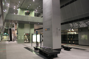
Nicoll Highway (CC5) is an underground Mass Rapid Transit (MRT) station on the Circle Line.
History
| Date | Event |
|---|---|
| 17 April 2010 | Station officially opens |
Nicoll Highway collapse
On 20 April 2004, a section of tunnel being built for the Circle Line collapsed, apparently when a retaining wall used in the tunnel's construction gave way. This occurred near what was to become the Nicoll Highway station, not far from the Merdeka Bridge.
The accident left a collapse zone 150 m wide, 100 m long, and 30 m deep. Four workers were killed, with three more injured and one body which was never recovered. The collapse set back the completion of the Circle Line Stage 1 from 2008 to 17 April 2010.[1]
Art in Transit
Re-claiming the Peripherals by Khiew Huey Chian features how different subjects relating to a place can be developed through various shapes and formations of wild plants which was frequently overlooked in Singapore. It also show that anything can be of value if we just keep an open mind to observe the potential of things around us.
Layout
| L2 | Overhead Bridge | The Concourse, Citygate, St John HQ |
|---|---|---|
| L1 | Street Level | |
| B1 | Service Level | Restricted access |
| B2 | Concourse | Faregates, Ticketing Machines, Passenger Service Centre |
| B3 | Platform B | Template:RailRoute/8 |
| Platform A/B | ||
| Platform A | Template:RailRoute/2 | |
Exits
| Exit | Disabled-Access | Location/Nearby |
|---|---|---|
| A | Nicoll Highway, The Concourse | |
| B | Republic Avenue, Marina Promenade |
Transport Services
First/Last Train Timing
| Destination | First Train | Last Train | ||
|---|---|---|---|---|
| Mon − Fri | Sat | Sun & P.H. | Daily | |
| File:MRT000.png Circle Line
Template:MRTTime Template:MRTTime Template:MRTTime Template:MRTTime Template:MRTTime Template:MRTTime Template:MRTTime Template:MRTTime | ||||
Bus
| Bus Stop | Exit | Bus Service |
|---|---|---|
| 80161 | Opp Nicoll Highway Stn |
|
| 80169 | Nicoll Highway Stn |
References
- ↑ "Transport minister announces next phase of Circle Line will open on Apr 17". Channel NewsAsia. 26 Jan 2010
| [ V • T • E ] | ||
|---|---|---|
| Stations | Dhoby Ghaut • Bras Basah • Esplanade • Promenade • Nicoll Highway • Stadium • Mountbatten • Dakota • Paya Lebar • MacPherson • Tai Seng • Bartley • Serangoon • Lorong Chuan • Bishan • Marymount • Caldecott • Bukit Brown • Botanic Gardens • Farrer Road • Holland Village • Buona Vista • one-north • Kent Ridge • Haw Par Villa • Pasir Panjang • Labrador Park • Telok Blangah • HarbourFront | |
| CCL6Keppel • Cantonment • Prince Edward Road | ||
| Circle Line ExtensionPromenade • Bayfront • Marina Bay | ||
| Rolling Stock | 830 • 830C • 851E | |
| Depots | Kim Chuan | |
| Others | Bridging Service | |
