Difference between revisions of "Nicoll Highway station"
m (→Layout) |
m (→Layout) Tag: Manual revert |
||
| (3 intermediate revisions by the same user not shown) | |||
| Line 64: | Line 64: | ||
{| class="mw-collapsible mw-collapsed" style="width:100%;" | {| class="mw-collapsible mw-collapsed" style="width:100%;" | ||
!{{Layout/Platform|B|CCL}} | !{{Layout/Platform|B|CCL}} | ||
|style='padding-right:.5em;'|{{Layout/Arrow|CCL|180}} <span style="display:inline-block;vertical-align:middle;"><span style="display:block;text-align:left;>{{Layout/Station|CC1}}</span><span style="display:block;text-align:left;>{{Layout/Station|CE2}}</span></span> | |style='padding-right:.5em;'|{{Layout/Arrow|CCL|180}} <span style="display:inline-block;vertical-align:middle;"><span style="display:block;text-align:left;>{{Layout/Station|CC1}}</span><span style="display:block;text-align:left;>{{Layout/Station|CE2}} <small> via {{Layout/Station|CC4}}</small></span></span> | ||
|style='padding-left:.5em;border-left:1px solid;width:200px'|'''Service Map''' | |style='padding-left:.5em;border-left:1px solid;width:200px'|'''Service Map''' | ||
|- | |- | ||
| Line 106: | Line 106: | ||
{|class="wikitable" | {|class="wikitable" | ||
!width=240|Bus Stop!!width=30|Exit!!width=300|Bus Service | !width=240|Bus Stop!!width=30|Exit!!width=300|Bus Service | ||
{{BusGuide|{{BS80161}}|A}}{{Bus/10}} {{Bus/14}} {{Bus/16}} {{Bus/16|a=M}} {{Bus/70}} {{Bus/70|a=M}} {{Bus/196}} | {{BusGuide|{{BS80161}}|{{Exit/Cell|A}}}}{{Bus/10}} {{Bus/14}} {{Bus/16}} {{Bus/16|a=M}} {{Bus/70}} {{Bus/70|a=M}} {{Bus/196}} | ||
{{BusGuide|{{BS80169}}|A}}{{Bus/10}} {{Bus/14}} {{Bus/16}} {{Bus/16|a=M}} {{Bus/70}} {{Bus/70|a=M}} {{Bus/196}} | {{BusGuide|{{BS80169}}|{{Exit/Cell|A}}}}{{Bus/10}} {{Bus/14}} {{Bus/16}} {{Bus/16|a=M}} {{Bus/70}} {{Bus/70|a=M}} {{Bus/196}} | ||
|} | |} | ||
Latest revision as of 18:45, 6 April 2024
!
|
TRAVEL ADVISORY | !
| ||||
|---|---|---|---|---|---|---|
On Sunday, 24 November 2024, Bus Services , , & will be affected by road closure on Nicoll Highway from the First Bus to 10.00am. Please refer here for more information. 
| ||||||
| CC5 Nicoll Highway 尼诰大道 நிக்கல் நெடுஞ்சாலை*Graphic From SGTrains/Wikipedia/LTA | |
| Statistics | |
|---|---|
| Address | 20 Republic Avenue Singapore 038970 |
| Line(s) | Circle Line |
| Structure | Underground |
| Connections | |
| Abbreviation | NCH |
Nicoll Highway (CC5) is a Mass Rapid Transit (MRT) station on the Circle Line.
History[edit]
| Date | Event |
|---|---|
| 17 April 2010 | Station officially opened |
Nicoll Highway collapse[edit]
On 20 April 2004, a section of tunnel being built for the Circle Line collapsed, apparently when a retaining wall used in the tunnel's construction gave way. This occurred near what was to become the Nicoll Highway station, not far from the Merdeka Bridge. The accident left a collapse zone 150m wide, 100m long, and 30m deep. Four workers were killed, with three more injured and one body which was never recovered.[1]
Consequently, the station site was moved around 100m south of the initial location. Moreover, the tunnels between Promenade and Stadium were constructed on an alignment that bypassed the collapsed area.[2] The collapse also resulted in the completion of Circle Line 1 being pushed back from 2008 to 2010.
Artworks[edit]

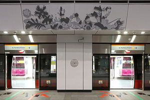
Circle Line: Re-Claiming The Peripherals by Khiew Huey Chian
Four large reliefs above the platform doors showcase overlooked wild plants that play a key role in holding soil together on reclaimed land, which the station was built on. The artwork gives a starring role to these unappreciated plants and aims to remind commuters of how there is value in everything if they just take a closer look.[3]
Layout[edit]
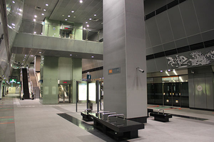
| L2 | Overhead Bridge | The Concourse, Citygate, St John HQ | ||||||
|---|---|---|---|---|---|---|---|---|
| L1 | Street Level | |||||||
| B1 | Service Level | Restricted access | ||||||
| B2 | Concourse | Faregates, Ticketing Machines, Passenger Service Centre | ||||||
| B3 |
| |||||||
| Platform A/B | ||||||||
| ||||||||
Exits[edit]
| Exit | Disabled-Access | Location/Nearby |
|---|---|---|
| A | Nicoll Highway, The Concourse | |
| B | Republic Avenue, Marina Promenade |
Transport Services[edit]
First/Last Train Timing[edit]
| Destination | First Train | Last Train | ||
|---|---|---|---|---|
| Mon − Fri | Sat | Sun & P.H. | Daily | |
| CC1Dhoby Ghaut | 05:48 | 05:48 | 06:15 | 23:57 |
| CC29HarbourFront | 05:45 | 05:45 | 06:12 | 22:56 |
| CC26Pasir Panjang | – | – | – | 23:26 |
| CC23one-north | – | – | – | 23:42 |
| CC17Caldecott | – | – | – | 00:10 |
| CC11Tai Seng | – | – | – | 00:17 |
| CC6Stadium | 06:07 | 06:07 | 06:30 | 00:01 |
| CE2Marina Bay | 06:12 | 06:12 | 06:33 | 23:46 |
Bus[edit]
- More travel information: Alternative Travel Method
| Bus Stop | Exit | Bus Service | |
|---|---|---|---|
| Opp Nicoll Highway Stn Nicoll Highway |
|
||
| Nicoll Highway Stn Nicoll Highway |
|
References[edit]
- ↑ "Friday’s fatal mishap among worst worksite accidents since 2004 Nicoll Highway tragedy". TODAY. Archived on 19 July 2017.
- ↑ "NICOLL HIGHWAY PROJECT RESTARTED". TODAY (9 September 2005).
- ↑ "Art in Transit". Land Transport Authority.
| [ V • T • E ] | ||
|---|---|---|
| Stations | Dhoby Ghaut • Bras Basah • Esplanade • Promenade • Nicoll Highway • Stadium • Mountbatten • Dakota • Paya Lebar • MacPherson • Tai Seng • Bartley • Serangoon • Lorong Chuan • Bishan • Marymount • Caldecott • Bukit Brown • Botanic Gardens • Farrer Road • Holland Village • Buona Vista • one-north • Kent Ridge • Haw Par Villa • Pasir Panjang • Labrador Park • Telok Blangah • HarbourFront | |
| CCL6Keppel • Cantonment • Prince Edward Road | ||
| Circle Line ExtensionPromenade • Bayfront • Marina Bay | ||
| Rolling Stock | 830 • 830C • 851E | |
| Depots | Kim Chuan | |
| Others | Bridging Service | |
