Difference between revisions of "MRT & LRT Stations"
Jump to navigation
Jump to search
m |
|||
| Line 1: | Line 1: | ||
==Latest System Map== | ==Latest System Map== | ||
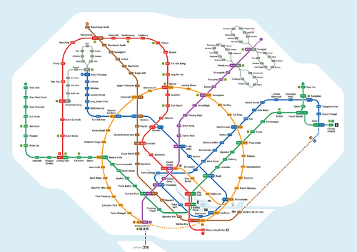
[[ | [[File:System Map.png|500px|centre|Latest System Map as of October 2017]] | ||
==Lines== | ==Lines== | ||
Revision as of 11:52, 22 October 2017
Latest System Map
Lines
| Railway Lines in Singapore | [ V • T • E ] | |
|---|---|---|
| Mass Rapid Transit (MRT) | North–South Line • East–West Line • North East Line • Circle Line • Downtown Line • Thomson–East Coast Line | |
| FutureJurong Region Line • Cross Island Line | ||
| Light Rail Transit (LRT) | Bukit Panjang LRT • Sengkang LRT • Punggol LRT | |
| Cross-border | KTM Intercity | |
| FutureJohor Bahru–Singapore Rapid Transit System | ||
| Others | Changi Airport Skytrain • Sentosa Express | |
| DefunctSentosa Monorail • Jurong Bird Park Panorail | ||
| [ V • T • E ] | ||
|---|---|---|
| Overview | History • Stations • Fare and Ticketing • Facilities • Safety • Security | |
| Lines | North–South Line • East–West Line • North East Line • Circle Line • Downtown Line • Thomson–East Coast Line
FutureJurong Region Line • Cross Island Line | |
| Rolling Stocks | 151 • 151A • 151B • 151C • R151 • T251 • 751A • 751C • 830 • 830C • 851E • 951
Future J151 • CR151 | |
| Depots | Bishan • Changi • Gali Batu • Kim Chuan • Mandai • Sengkang • Ulu Pandan • Tuas | |
| Future Changi East • East Coast • Tengah | ||
| [ V • T • E ] | ||
|---|---|---|
| Overview | History • Stations • Fare and Ticketing • Facilities • Safety • Security | |
| Lines | Bukit Panjang LRT • Sengkang LRT • Punggol LRT | |
| Rolling Stocks | 801 • 801A • 801B • 810 • 810A | |
| Future810D | ||
| Depots | Sengkang • Ten Mile Junction | |
Station
Template:Singapore MRT stations Template:Singapore LRT stations
