Difference between revisions of "Queenstown station"
m |
Wekelwrady (talk | contribs) |
||
| (2 intermediate revisions by 2 users not shown) | |||
| Line 31: | Line 31: | ||
{| class="layout" | {| class="layout" | ||
!rowspan=3|L3 | !rowspan=3|L3 | ||
|colspan=2|{{ | |colspan=2| | ||
{| class="mw-collapsible mw-collapsed" style="width:100%;" | |||
!{{Layout/Platform|A|EWL}} | |||
|style='padding-right:.5em;'|{{Layout/Arrow|EWL|0}} <span style="display:inline-block;vertical-align:middle;"><span style="display:block;text-align:left;>{{Layout/Station|EW1}}</span><span style="display:block;text-align:left;>{{Layout/Station|CG2}} <small> via {{Layout/Station|EW4|xrs=0|xbss=none}}</small></span></span> | |||
|style='padding-left:.5em;border-left:1px solid;width:200px'|'''Service Map''' | |||
|- | |||
|colspan=3| | |||
<div style='overflow-x:scroll;white-space:nowrap;max-width:75vw;'> | |||
{{Layout/Map|EW19|#000|#fff|c=EWL}} {{Layout/Map|EW18|c=EWL}} {{Layout/Map|EW17|c=EWL}} {{Layout/Map|EW16|c=EWL}} {{Layout/Map|EW15|c=EWL}} {{Layout/Map|EW14|c=EWL}} {{Layout/Map|EW13|c=EWL}} {{Layout/Map|EW12|c=EWL}} {{Layout/Map|EW11|c=EWL}} {{Layout/Map|EW10|c=EWL}} {{Layout/Map|EW9|c=EWL}} {{Layout/Map|EW8|c=EWL}} {{Layout/Map|EW7|c=EWL}} {{Layout/Map|EW6|c=EWL}} {{Layout/Map|EW5|c=EWL}} {{Layout/Map2|EW4|c=EWL|l={{Layout/Map-BR|off=-6em|c=EWL}}}} <span style="display:inline-block;vertical-align:top;><span style="display:block;text-align:left;">{{Layout/Map|EW3|c=EWL}} {{Layout/Map|EW2|c=EWL}} {{Layout/Map|EW1|c=EWL|r=}}</span><span style="display:block;text-align:left;">{{Layout/Map|CG1|c=EWL}} {{Layout/Map|CG2|c=EWL|r=}}</span></span> | |||
</div> | |||
|} | |||
|- | |- | ||
|colspan=2 class="platform"|Platform A/B | |colspan=2 class="platform"|Platform A/B | ||
|- | |- | ||
|colspan=2|{{ | |colspan=2| | ||
{| class="mw-collapsible mw-collapsed" style="width:100%" | |||
!{{Layout/Platform|B|EWL}} | |||
|style='padding-right:.5em;'|{{Layout/Arrow|EWL|180}} {{Layout/Station|EW33}} | |||
|style='padding-left:.5em;border-left:1px solid;width:200px'|'''Service Map''' | |||
|- | |||
|colspan=3| | |||
<div style='overflow-x:scroll;white-space:nowrap;max-width:75vw;'> | |||
{{Layout/Map|EW33|c=EWL}} {{Layout/Map|EW32|c=EWL}} {{Layout/Map|EW31|c=EWL}} {{Layout/Map|EW30|c=EWL}} {{Layout/Map|EW29|c=EWL}} {{Layout/Map|EW28|c=EWL}} {{Layout/Map|EW27|c=EWL}} {{Layout/Map|EW26|c=EWL}} {{Layout/Map|EW25|c=EWL}} {{Layout/Map|EW24|c=EWL}} {{Layout/Map|EW23|c=EWL}} {{Layout/Map|EW22|c=EWL}} {{Layout/Map|EW21|c=EWL}} {{Layout/Map|EW20|c=EWL}} {{Layout/Map|EW19|#000|#fff|c=EWL|r=}} | |||
</div> | |||
|} | |||
|- | |- | ||
!width=25|L2 | !width=25|L2 | ||
| Line 75: | Line 95: | ||
{|class="wikitable" | {|class="wikitable" | ||
!width=240|Bus Stop!!width=30|Exit!!width=300|Bus Service | !width=240|Bus Stop!!width=30|Exit!!width=300|Bus Service | ||
{{BusGuide|{{BS11141}}|A/D}}{{Bus | {{BusGuide|{{BS11141}}| {{Exit/Cell|A}} {{Exit/Cell|D}} }}{{Bus/51}} {{Bus/111}} {{Bus/145}} {{Bus/186}} {{Bus/195}} {{Bus/970}} | ||
{{BusGuide|{{BS11149}}|B/C}}{{Bus | {{BusGuide|{{BS11149}}| {{Exit/Cell|B}} {{Exit/Cell|C}} }}{{Bus/51}} {{Bus/111}} {{Bus/145}} {{Bus/186}} {{Bus/195}} {{Bus/970}} | ||
|} | |} | ||
Latest revision as of 17:30, 27 December 2022
!
|
TRAVEL ADVISORY | !
| ||||
|---|---|---|---|---|---|---|
On Sunday, 24 November 2024, Bus Services , , & will be affected by road closure on Nicoll Highway from the First Bus to 10.00am. Please refer here for more information. 
| ||||||
| EW19 Queenstown 女皇镇 குவீன்ஸ்டவுன்*Graphic From SGTrains/Wikipedia/LTA | |
| Statistics | |
|---|---|
| Address | 301 Commonwealth Avenue Singapore 149729 |
| Line(s) | East–West Line |
| Structure | Elevated |
| Connections | |
| Abbreviation | QUE |
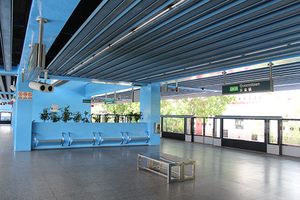
Queenstown (EW19) is a Mass Rapid Transit (MRT) station on the East–West Line.
History[edit]
| Date | Event |
|---|---|
| 12 March 1988 | Station officially opened |
| 10 December 2017 | Station closed due to the upgrading of signaling system on the East–West Line[1] |
| 17 December 2017 |
2010 incident[edit]
On 29 November 2010, a Chinese man in his 40s was knocked by an incoming train at about 8.15pm, was found lying on the tracks below the last carriage and was pronounced dead by SCDF medics. Train services were disrupted for about 1 hour and were resumed at 9.15pm.[2]
Layout[edit]
| L3 |
| |||||||
|---|---|---|---|---|---|---|---|---|
| Platform A/B | ||||||||
| ||||||||
| L2 | Concourse | Faregates, Ticketing Machines, Passenger Service Centre | ||||||
| L1 | Street Level | |||||||
Exits[edit]
| Exit | Disabled-Access | Location/Nearby |
|---|---|---|
| A | Commonwealth Avenue, True Way Presbyterian Church | |
| B | Commonwealth Avenue, Strathmore Avenue | |
| C | Commonwealth Avenue | |
| D | Commonwealth Avenue, Queenstown Stadium |
Transport Services[edit]
First/Last Train Timing[edit]
| Destination | First Train | Last Train | ||
|---|---|---|---|---|
| Mon − Fri | Sat | Sun & P.H. | Daily | |
| EW1Pasir Ris | 05:47 | 05:47 | 06:15 | 23:55 |
| EW33Tuas Link | 06:12 | 06:12 | 06:38 | 00:10 |
Bus[edit]
- More travel information: Alternative Travel Method
| Bus Stop | Exit | Bus Service | ||
|---|---|---|---|---|
| Queenstown Stn Exit A/D C'wealth Ave |
|
|||
| Queenstown Stn Exit B/C C'wealth Ave |
|
References[edit]
- ↑ "2 full-day shutdowns, shorter operating hours for 19 NSEWL MRT stations in December: LTA, SMRT". Channel NewsAsia (21 November 2017).
- ↑ "Man dead at Queenstown MRT station". AsiaOne.
| [ V • T • E ] | ||
|---|---|---|
| Stations | Pasir Ris • Tampines • Simei • Tanah Merah • Bedok • Kembangan • Eunos • Paya Lebar • Aljunied • Kallang • Lavender • Bugis • City Hall • Raffles Place • Tanjong Pagar • Outram Park • Tiong Bahru • Redhill • Queenstown • Commonwealth • Buona Vista • Dover • Clementi • Jurong East • Chinese Garden • Lakeside • Boon Lay • Pioneer • Joo Koon • Gul Circle • Tuas Crescent • Tuas West Road • Tuas Link
Changi Airport ExtensionTanah Merah • Expo • Changi Airport | |
| Rolling Stock | 151 • 751B • 151A • 151B • 151C • R151
Former651 | |
| Depots | Changi • Ulu Pandan • Tuas • East Coast | |
| Others | Bridging Service | |
