Alternative Travel Method/Pasir Panjang
From SgWiki
Revision as of 00:43, 24 April 2024 by Wekelwrady (talk | contribs)
(diff) ← Older revision | Latest revision (diff) | Newer revision → (diff)
Notes
- The suggested route assumed that there is no train disruption on the rest of the MRT network.
- The list of bus service plying between the bus stops are listed accordingly by their similar travelling time and not by the origin-destination pair.
Circle Line[edit]
Dhoby Ghaut to MacPherson[edit]
| Going To | ExpandRoute(s) | |||||||||||||||||
|---|---|---|---|---|---|---|---|---|---|---|---|---|---|---|---|---|---|---|
| CC1NS24NE6Dhoby Ghaut |
| |||||||||||||||||
| CC2Bras Basah |
| |||||||||||||||||
| CC3Esplanade |
| |||||||||||||||||
| CC4DT15Promenade |
| |||||||||||||||||
| CC5Nicoll Highway | Opp Currency Hse Pasir Panjang Rd | CC26Pasir Panjang 10 [ 0 ~ 120 mins ] Opp Nicoll Highway Stn Nicoll Highway | CC5Nicoll Highway | |||||||||||||||
| CC6Stadium |
| |||||||||||||||||
| CC7Mountbatten |
| |||||||||||||||||
| CC8Dakota | Opp Currency Hse Pasir Panjang Rd | CC26Pasir Panjang 10 30 [ 0 ~ 120 mins ] Dakota Stn Exit A/Blk 99 Old Airport Rd | CC8Dakota | |||||||||||||||
| CC9EW8Paya Lebar |
| |||||||||||||||||
| CC10DT26MacPherson |
| |||||||||||||||||
Tai Seng to Botanic Gardens[edit]
| Going To | ExpandRoute(s) | |||||||||||||||||||||
|---|---|---|---|---|---|---|---|---|---|---|---|---|---|---|---|---|---|---|---|---|---|---|
| CC11Tai Seng |
| |||||||||||||||||||||
| CC12Bartley |
| |||||||||||||||||||||
| CC13NE12Serangoon |
| |||||||||||||||||||||
| CC14Lorong Chuan |
| |||||||||||||||||||||
| CC15NS17Bishan |
| |||||||||||||||||||||
| CC16Marymount |
| |||||||||||||||||||||
| CC17TE9Caldecott |
| |||||||||||||||||||||
| CC19DT9Botanic Gardens | Opp Currency Hse Pasir Panjang Rd | CC26Pasir Panjang 51 [ 0 ~ 120 mins ] Opp Queenstown Polyclinic Queensway | Queenstown Polyclinic 153 [ 0 ~ 120 mins ] Opp Botanic Gdns Stn Dunearn Rd | CC19DT9Botanic Gardens Singapore Botanic Gardens | ||||||||||||||||||
Farrer Road to HarbourFront[edit]
| Going To | ExpandRoute(s) | |||||||||||
|---|---|---|---|---|---|---|---|---|---|---|---|---|
| CC20Farrer Road | Opp Currency Hse Pasir Panjang Rd | CC26Pasir Panjang 51 175 [ 0 ~ 120 mins ] Alexandra Retail Ctr Alexandra Rd | 93 [ 0 ~ 120 mins ] Farrer Rd Stn Exit B Farrer Rd | CC20Farrer Road | ||||||||
| CC21Holland Village | Opp Currency Hse Pasir Panjang Rd | CC26Pasir Panjang 51 175 [ 0 ~ 120 mins ] Alexandra Retail Ctr Alexandra Rd | 61 [ 0 ~ 120 mins ] Holland V Stn/Blk 12 Holland Ave | CC21Holland Village | ||||||||
| CC22EW21Buona Vista |
| |||||||||||
| CC23one-north |
| |||||||||||
| CC24Kent Ridge |
| |||||||||||
| CC25Haw Par Villa |
| |||||||||||
| CC27Labrador Park | Opp Currency Hse Pasir Panjang Rd | CC26Pasir Panjang 10 30 51 143 175 176 188 [ 0 ~ 120 mins ] Opp Labrador Pk Stn Pasir Panjang Rd | CC27Labrador Park | |||||||||
| CC28Telok Blangah | Opp Currency Hse Pasir Panjang Rd | CC26Pasir Panjang 10 30 143 188 [ 0 ~ 120 mins ] Opp Telok Blangah Stn Telok Blangah Rd | CC28Telok Blangah | |||||||||
| CC29NE1HarbourFront |
| |||||||||||
Bayfront to Marina Bay[edit]
| Going To | ExpandRoute(s) | ||||||||||||||
|---|---|---|---|---|---|---|---|---|---|---|---|---|---|---|---|
| CE1DT16Bayfront |
| ||||||||||||||
| CE2NS27TE20Marina Bay |
| ||||||||||||||
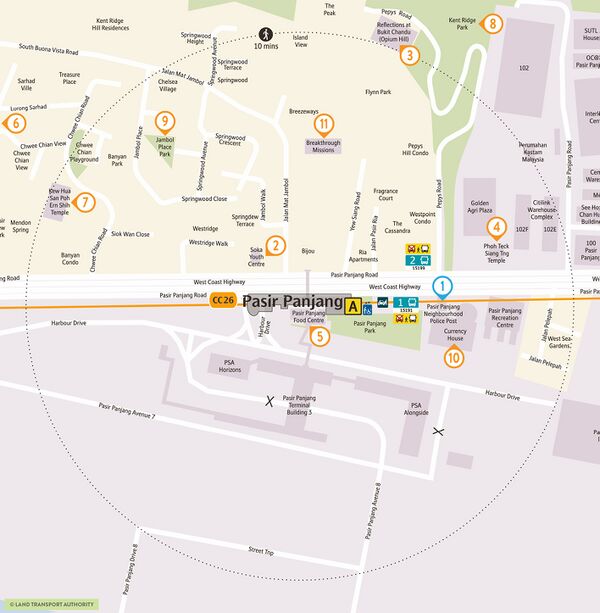
Reference Map[edit]
See Also[edit]
| [ V • T • E ] | ||
|---|---|---|
| Stations | Dhoby Ghaut • Bras Basah • Esplanade • Promenade • Nicoll Highway • Stadium • Mountbatten • Dakota • Paya Lebar • MacPherson • Tai Seng • Bartley • Serangoon • Lorong Chuan • Bishan • Marymount • Caldecott • Bukit Brown • Botanic Gardens • Farrer Road • Holland Village • Buona Vista • one-north • Kent Ridge • Haw Par Villa • Pasir Panjang • Labrador Park • Telok Blangah • HarbourFront | |
| CCL6Keppel • Cantonment • Prince Edward Road | ||
| Circle Line ExtensionPromenade • Bayfront • Marina Bay | ||
| Rolling Stock | 830 • 830C • 851E | |
| Depots | Kim Chuan | |
| Others | Bridging Service | |
